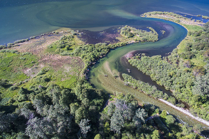
It has happened before, and it will happen again: The mouth of Kokanee Creek will (abruptly) shift to the east.
The portion of the delta immediately to the west of the creek mouth is strewn with gullies and ponds. These are the older channels of the creek. Two years ago (February 2015) I wrote about this and showed pictures of this terrain under the title, wandering creek. I also showed pictures of the bank slump along the berm where, I believe, the creek will, in a few years, break through and flow into the grasslands to the east.
Since that time, this berm of soil and brush between the creek and the grasslands has become thinner and thinner as the creek has continued to erode it.
Such erosion is a natural process when a creek or river flows through gentle terrain: Material on the outside of a bend is transferred to the inside causing the channel to shift. When flowing down a steep mountain valley, the stream is constrained. But, on a delta, the creek bed wanders. Of course, around Kootenay Lake, there are settlements on most creek deltas, with the result that humans use concrete or riprap to prevent such wandering.
To a good extent, the stewardship of Kokanee Creek Park has been left to the devices of nature. One result is that near its mouth, the creek occasionally shifts course. When the next big course change takes place, I suspect it will happen fairly quickly. It will be fun to be able to watch geology in action as the creek breaks through into the grasslands on the east side (left) of the picture and leaves behind more ponds on the west side (right).
This is a view of the mouth of Kokanee Creek as it flows into Kootenay Lake. The region of interest is the outside of the bend that appears in the centre of the picture. It is here that the berm of dirt and brush protecting the grasslands is eroding rapidly and will soon break.


Fine post, Alistair.