Not seen here


This blog is about the region around Kootenay Lake, but it is sometimes useful to recognize what cannot be seen here. This posting shows two pictures of a Greater Yellowlegs. Although occasionally this sandpiper is seen around the Lake, the particular bird shown could not have been photographed here. I wonder why this might be?

Posted in birds | 4 Comments

Knees-up eagle


The sub-adult Bald Eagle is often mistaken for a Golden Eagle for they both can have a mixture of brown and white plumage, but they differ in other ways. Yesterday’s Bald Eagle looks as if it were hatched last summer. 

An overflight reveals the mottled plumage of a nearly year-old Bald Eagle.

“I am practicing for a dance competition doing Knees Up Mother Brown.”

Posted in birds | 1 Comment

Black-tailed Deer


The mule deer and the black-tailed deer are the same species, but different subspecies. They have been separated by the Coastal Range of mountains so long that they have evolved a somewhat different appearance and behaviour. While the region around Kootenay Lake has both the white-tailed deer and the mule deer, it lacks the black-tailed deer.

First a earlier picture of a mule deer near the Lake. Its rope-like tail is largely white, but has a black tip.

This black-tailed deer was seen yesterday just west of the crest of the Coastal Mountains. The black on its tail extends the full length, and the whole deer is somewhat darker.

Posted in mammals | 1 Comment

From ice to flowers


In a lovely example of a seasonal transition, I saw ice extrusions and subalpine buttercups within three metres of each other at an altitude of about 800 metres on a mountainside above Kootenay Lake. 

Typically, ice extrusions are seen when the daytime temperature is above 0C and the nighttime temperature is below, so this is not a midwinter phenomenon. During daytime, water drains into the cavities within a porous soil; during nighttime, the freezing water expands forcing little columns of ice up through the ground (often capped with dirt). Those of us who remember the home delivery of milk to a cold doorstep in the winter are already familiar with the process whereby the cap of the milk bottle was lifted atop a column of frozen cream. When I wrote about these a year ago, a commentator noted that geologists refer to these as ice needles, a name that has a different meaning for meteorologists.

About three metres away was a crop of a dozen (what I suspect were) subalpine buttercups (Ranunculus eschscholtzii), an early sping flower — lovely.

And for fun, I include a picture from the same spot, but looking down towards Kokanee Creek Peninsula.

Posted in weather, wildflowers | 3 Comments

Ruff practice


The winter has passed without any of the Ruffed Grouse in my yard displaying their ruffs. Now that the mating season is approaching, a male grouse was seen to flash some of his ruff without ever opening it completely. What seemed half-hearted now should get serious soon when the grouse’s display is used to both intimidate other males and attract females.

A male Ruffed Grouse shows a bit of its black ruff as if practicing for the forthcoming mating season.

Posted in birds | 1 Comment

Psychedelic BOB


BOB is Nelson’s Big Orange Bridge.

Alas, its truss design is more functional than lovely. Even when built in 1957, I remember thinking that a more beautiful bridge would better suit its setting. Curiously, the bridge’s ugliness did not prevent it from becoming — indeed, may have encouraged it to become — a local icon. 

Although the truss design suffers from industrial unsightliness, it does offer some interesting mapping projections of a full-sphere image. I might explore these from time to time. 

The centre of this full-sphere image of BOB looks west towards the afternoon sun.


Posted in commentary, scenes | 4 Comments

Frenetic and languid


Two days ago in the Park, I watched one of the most frenetic of birds: a Golden-crowned Kinglet. By the time it was spotted and the camera pointed, usually the bird was gone. 

Then yesterday, four Trumpeter Swans were spotted far along the shore. They remained in place as I walked the kilometre and a half. While not completely unconcerned by the passage of humans along the beach, they were certainly nonchalant. 

The Golden-crowned Kinglet is caught in a rare moment between bursts of speed.

It is not that it even seemed aware that it was being watched, but that it had to hurry to the next delectable.

It is instantly off again.

Contrasting the frenetic kinglets are the languid swans, which hardly moved for an hour.
 

Posted in birds | 3 Comments

KCPP boardwalk


I went out this morning to take a picture of the boardwalk at Kokanee Creek Provincial Park. By happenstance, this proved prescient for I discovered that it is soon to be replaced — by what, I do not yet know. Mind you, having slipped and fallen on a wet boardwalk a couple of times, I can understand the desirability of replacement. 

Here is an overview of the boardwalk. On the left is the path from the bridge over the creek. In the centre is the path over the spawning channel leading to the Visitors’ Centre. On the right is the path leading along the spawning channel towards the creek mouth and Lake. It is interesting to speculate how this might appear in a year,

Posted in scenes | 2 Comments

Fifty years ago


Observe, photograph, interpret, publish. For fifty years I have been remarkably consistent with a procedure that I described for a forthcoming article in Wildlife Afield: Photography is my muse as I explore the natural world.

While the roots of this behaviour extend to childhood, this March marks the fiftieth anniversary of my having completed all the steps. It was on the 11th of January 1965 that I watched something interesting in the Grand Teton National Park (Wyoming, USA), took pictures, and speculated on the cause. The resulting article was published as SOME FOG, AN INVERSION, AND A THERMAL in March of 1966 in a magazine of the Royal Meteorological Society (Weather, Vol. 21, Issue 3, pp 76 – 77).

As I reread that article, I find the pictures and the discussion of the flow of air were good, but my discussion of the flog formation was wanting. What can I say? I was a student at the time and, not surprisingly, my skills in making sense of the natural world have developed over the intervening half century. Indeed, time has also improved image quality, and shortened the time for image acquisition and publication.

Now, fifty years later, I present the original images and use some of the original text for their captions.

— begin quoted material —

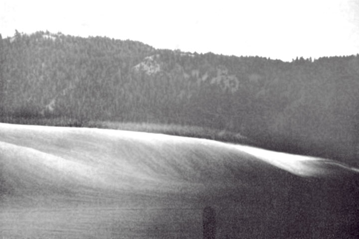
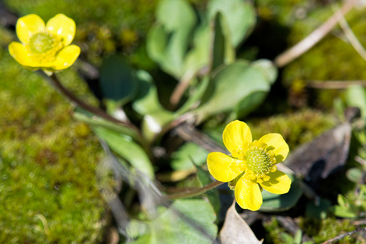
While driving through the Grand Teton National Park in Wyoming at sunset on 11 January 1965, I was intrigued by the way a thin skin of fog flowed down off the hills in the east, across the highway and on down to the valley floor. The fog, though no more than a foot thick, was gliding about 3 or 4 ft above the snow surface like a huge bed-sheet. It appeared to be a water fog and was moving at about 4 to 6 miles/hr. [This] is a view looking to the south-east. One can see the skin of fog moulding itself to the curves of the snow slopes as it flows roughly from left to right. The narrow ridge visible in the first picture provided an interesting verification that the fog was indeed drainage.

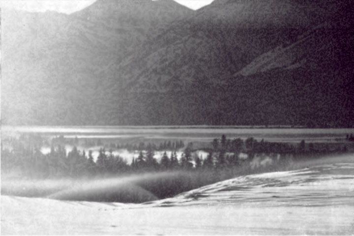
A fascinating aspect of the whole scene occurred after the fog sheet had flowed across the road and was making its way down to the valley floor where hot springs abound. Clouds produced by the hot springs are visible among the trees. One such hot spring apparently lay just over the bank from where the picture was taken. A moist thermal which formed over it was trapped from its inception under the inversion at the top of the drainage fog sheet. The thermal found, however, that it could flow up the side of the bank and remain under the inversion, but upon reaching the top of the bank it had nowhere to go but to try unsuccessfully to break through the inversion. The top of the thermal is outlined in fog due to mixing and cooling at its surface as it passed through the cold-drainage air. The second picture shows its maximum penetration into the inversion. The thermal would then collapse, only to reform and make another unsuccessful assault. The whole process was repeated every 1 or 2 minutes. So captivating was this battle between the thermal and the inversion, which was manifest by the thin fog layers, that I neglected to collect sufficient data to construct a sounding.

— end quoted material —

So, what was going on? I offered correct interpretations of both the shallow katabatic wind flowing towards the valley bottom and of the thermals rising from the hot springs to meet it. However, my treatment of the fog formation was muddled. The fog would have actually resulted from vapour mixing at the interface between the shallow layer of cold air draining down the slope and the overlying air. The same is true of the fog in the shell surrounding the thermals. 

While my original interpretation was uneven, it was a good beginning to a lifetime of using pictures as an aid to making sense of the natural world — a practice that persists in this blog. 

Posted in commentary, weather | 4 Comments

Beach source


Two months ago, in winter tranquility, I noted that most treatments of the seasonal changes of beaches consider only those around oceans or flatland lakes, but ignore the rather different behaviour of mountain lakes.

At the risk of whingeing, this posting picks up on that theme and considers the source of the sand. A way to assess the problem that might be faced by a local science teacher is that authoritative sources on beach formation, such as Wikipedia, says that:

Beaches are the result of wave action…. Beach materials come from erosion of rocks offshore, as well as from headland erosion…

So, the claim is that waves pound the shoreline and break up rocks and headland into small particles that then form our beaches. Alas, that just does not seem to describe what happens around here. Rather, it is the many creeks flowing into our Lake that carry the sand that produces the beaches, each of which sits in the vicinity of a creek mouth.

A mountain creek scours its bed. It certainly smashes rocks creating fragments, but then transports smaller particles downstream to the Lake. It is this debris that forms our beaches.

Mind you, once this sediment arrives, waves move it along the shore by a process that is referred to as longshore drift. However, the source of the sand is not the bashing of that shoreline by waves (which are rather small anyway), but the deposition of the multitudinous creeks that flow into the Lake. It is during the spring freshet that creeks transport most of the sand that gets added to beaches. But, any significant rainfall will swell creeks and do likewise, as is seen in the picture, below. 

 This tiny creek is one of hundreds that transport sand down the mountainside to the Lake and then spread it along the shore to create our beaches.

Posted in weather | 3 Comments